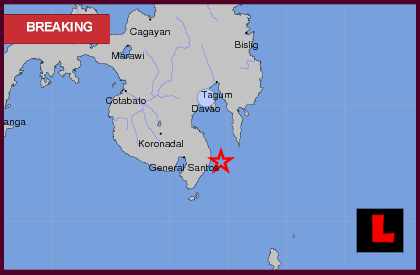
| A moderate earthquake has occurred with these revised parameters: |
| Time of Occurrence : 4.01 am on 19 November 2012 |
| Coordinates : 6.0 North 126.0 East |
| Location : Mindanao, Philippines.111km Southeast of Digos City,Philippine.849km Northeast of Semporna,Sabah. |
| Magnitude : 5.2 on Richter scale News reports : Philippines Earthquake Today 2012 Shakes Mindanao LOS ANGELES (LALATE) – A Philippines earthquake today 2012 has struck Mindanao. The Philippines earthquake today Monday, November 19, 2012 struck in the predawn morning hours. No reports of damage has yet to be indicated by local news. Officials tell news that a 5.1 magnitude Philippines earthquake erupted locally Monday shortly after 4 am. The quake, however, had a substantial depth. USGS indicates to news that the quake struck seventy-eight miles below the earth’s surface. As a result, the quake’s range was limited.
Philippines August Earthquake Maps
USGS indicates to news that the Philippines earthquake today began thirteen miles east of Lamitan and seventeen miles east of Caburan. The quake was also thirty-two miles east of Malita and forty miles east of Alabel.Philippines Earthquake Map 1 Philippines Earthquake Map 2 Philippines Earthquake Map 3 Philippines Earthquake Map 4 In August, the country was rocked by a 7.6 magnitude quake. Then, a series of substantial aftershock quakes continued to erupt across the region. Those quakes had a shallow depth and were close to populated regions, officials told news. In June, a 5.5 magnitude quake erupted east of Mindanao as well. USGS indicated to news, at the time, that the June quake struck ninety-five miles east of Mindanao town General Santos. It was centered one hundred fourteen miles south of Davao. |
`
THERE IS NO GOD EXCEPT ALLAH
read:
Monday, November 19, 2012
5.2 EARTHQUAKE AT MINDANAO, PHILIPPINES
Subscribe to:
Post Comments (Atom)


No comments:
Post a Comment
Note: Only a member of this blog may post a comment.