


The report on the July 4 Baling floods, released last week, is defective as it does not investigate how regulations were breached to develop a durian plantation in the Gunung Inas Forest Reserve, Bukit Bendera MP Wong Hon Wai said.
The Energy and Natural Resources Ministry’s report on the causes of the fatal floods, which killed three and displaced more than 3000 residents, was released last Friday.
"This report is just an explanation from the geological perspective. It is incomplete and does not have the chronology of events pertaining to changes to land use by the Kedah government, the approvals provided and the details of the environmental impact assessment (EIA) of the federal government.
"The report also does not investigate why the land use was changed and how the EIA procedure was breached, and other possible breaches of the law.
"I want to stress that what happened in Baling was not natural but was caused by humans who did not respect nature or the law," he said in a statement.
Wong added the report also fails to mention that Musang King durian, which was planted in the cleared land, is not a species allowed for forest plantation projects.
"This is evidence that the procedures were not adhered to," he said.
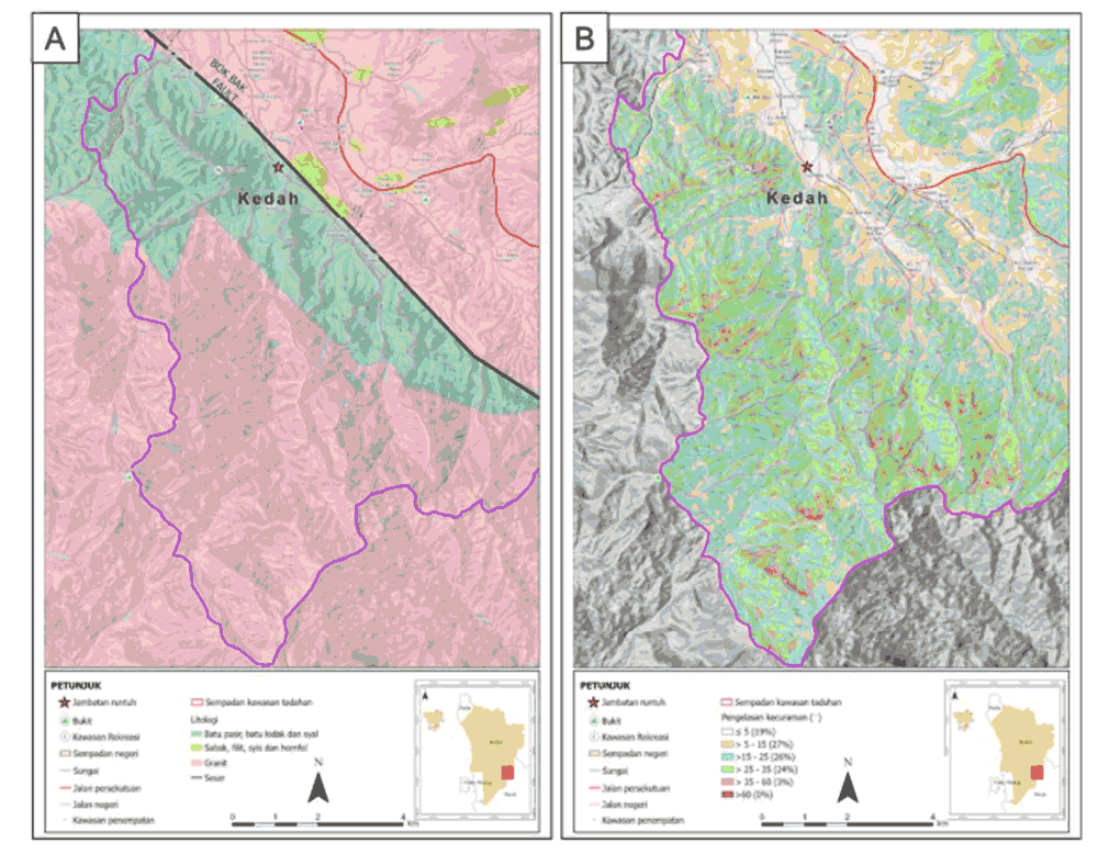
The report concluded that the disaster, estimated to cost RM25.91 million in losses, was mainly caused by land erosion and the movement of debris in the highland, which caused the debris to flow into Sungai Kupang.
It added a secondary cause was the land clearing of 5,000 hectares in Compartment 8 of the forest reserve, of which 823 hectares were planted with rubber and durian trees.
"The changes in land used exacerbated the rate of erosion. Piles of material from previous erosion combined with new erosion during heavy rainfall on July 4 also contributed to the increase in debris which was picked up by the flow, leading to the flood," the report stated.
Residents must be relocated
According to the report, the flood also destroyed 17 homes, displaced 3,545, demolished 11 bridges and flooded hundreds of homes with mud.
However, Wong said it does not take into account the repercussions on tens of thousands of Kedah residents outside of Baling and in neighbouring Penang, who faced several days of water cuts.
This was because the Sungai Dua water treatment centre was closed when the water from the intake point in Sungai Muda became muddy.

Wong said despite the shortcomings of the report, the report's 10 short-term and four long-term recommendations should still be undertaken on an urgent basis.
The short-term measures recommended include:
Relocate residents living within established danger zones, as more floods are expected in the next few months because the river has become up to two metres more shallow from the flow of debris;
Install an automatic rainfall measurement system near the peak of Gunung Inas to obtain real-time data, which can be used as an early warnings system;
Conduct a detailed mapping of the geological flow of Sungai Kupang within six months;
Regular monitoring and removal of debris material, including stones and wood debris upstream;
Plant more greenery immediately as land cover to avoid further erosion and building a siltation trap in the plantation area;
Make an urgent decision on whether the forest plantation project can continue, and if so, improve measures to minimise erosion;
Protect part of Compartment 8 of Gunung Inas Forest Reserve as a forest and wildlife corridor; and
Training to build local capacity and that among technical agencies to deal with similar disasters.
Long-term measures recommended include:
Establish a national centre of research on geological disasters to become a primary resource to mitigate and investigate geological disasters and to provide immediate forensic investigation in the event of a disaster;
Establish a national programme to map the flow of debris and areas at risk of similar disasters and to develop mitigation measures;
Develop a real-time monitoring and early warnings system for such disasters; and
Develop areas at risk of geological disasters in a way which does not exacerbate risks, including using such areas as ecotourism spots and for conservation.
"This can only be done after a detailed mapping of geological disaster risks is done and must be friendly to the local community and the environment," the report read. - Mkini
No comments:
Post a Comment
Note: Only a member of this blog may post a comment.