


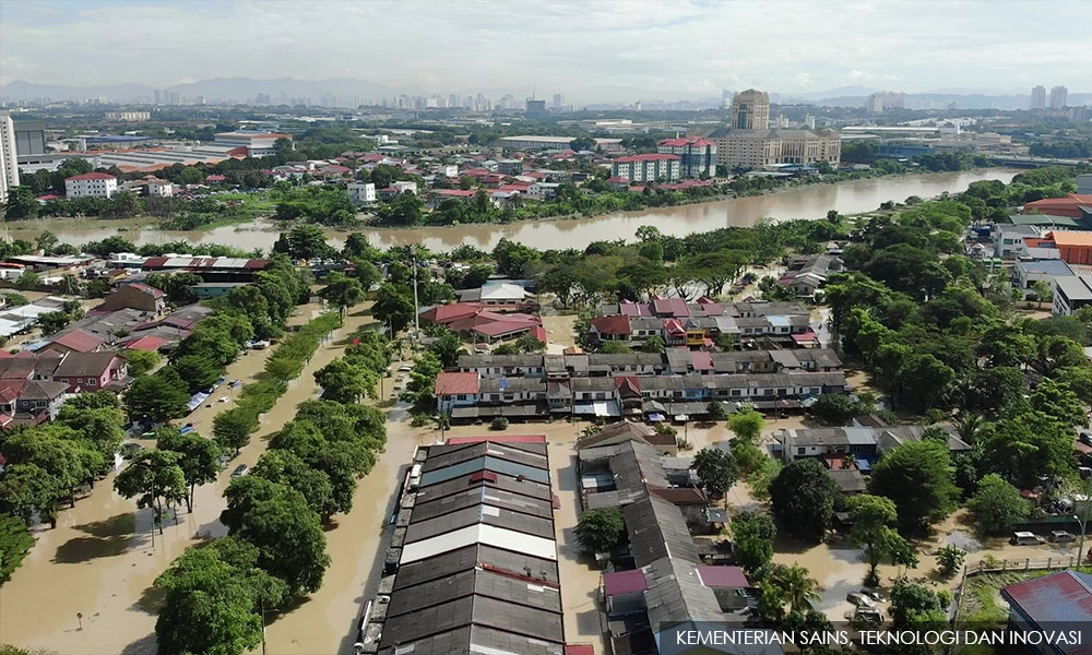
Malaysians were caught by surprise by the torrential downpour, caused by Tropical Depression 29W, throughout the peninsula for three days from Dec 17 which continued until Dec 19.
It resulted in a peak daily rainfall of 363mm, equivalent to a month's worth of rainfall in the region worst affected, Selangor.
Klang and Shah Alam in Selangor were the most affected areas. Some areas in the state of Pahang too were ravaged by the floods.
As of Dec 27, 48 persons perished due to these floods and five are still missing.
This deadliest tropical cyclone-related disaster to hit Malaysia demonstrated the nation was ill-prepared to respond to this crisis.
Global warming linked to extreme weather including worsening floods was among the factors attributed to this climate crisis.
Furthermore, with the mass movement of people, there were fears of Covid-19 cases and deaths escalating.
Public fury
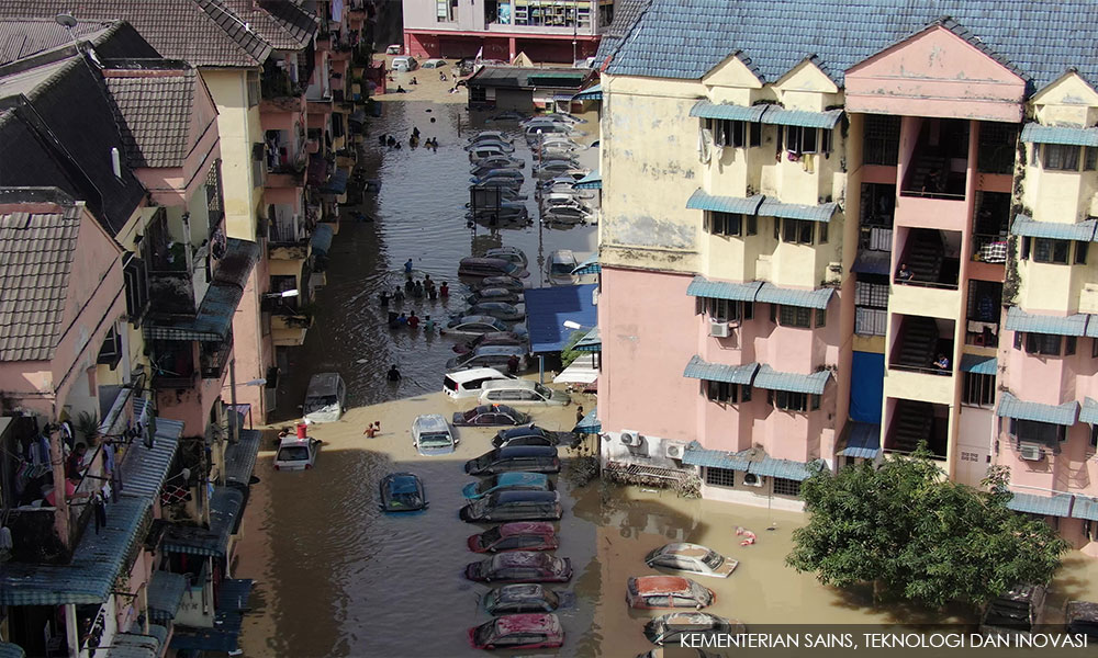
There were videos of many stranded on rooftops, suffering from cold and hunger, with no immediate rescue from relevant government agencies. Those stranded were offered help and support by caring fellow citizens and NGOs.
This sparked the public’s anger at the role and response of the government to and during this crisis.
Among key issues raised included no early warning of the torrential rain as well as the uncoordinated and slow response in rescue and relief efforts by the relevant authorities.
Prime Minister Ismail Sabri Yaakob explained that rescue teams had difficulties getting into Taman Sri Muda as floodwaters rose rapidly and were unable to carry out their work as roads were also blocked by stranded vehicles.
Additionally, the premier said rescue teams faced problems initially responding to victims stranded on rooftops as they could not see the addresses as the road signs had been submerged.
As it is globally recognised that the probability of finding survivors is highest within the immediate 72 hours following a disaster, the slow rescue and relief efforts caused grave concerns that the death toll and damage to properties would further escalate.
As floods become more severe and more frequent, governments and authorities across multiple levels of government - district, state, and national - must embrace and invest in advanced technologies which are revolutionising disaster management efforts.
One of the many challenges of responding to a natural disaster is the difficulty in determining the location and extent of the damage including the location of victims for effectively mobilising rescue and relief efforts.
Several technologies including drones can be used to pinpoint the location of victims, damaged sites, buildings, floodplains, emergency service resources, and disaster relief sites.
Additionally, knowing where resources and relief centres are located will facilitate communication with various levels of government, about the resources they have and where and how to distribute these for flood victims, as well as to accommodate them in nearest relief centres.
Drone usage
Unmanned aerial vehicles (UAVs) aka aerial drones and Underwater Unmanned vehicles (UUV) are being used worldwide for a myriad of applications including aerial photography, agricultural monitoring, infrastructure inspection, construction, media production, as well as in research and development.
UAVs with various types of onboard sensors and advanced computer technologies are able to fly in life-threatening conditions.
They are fast becoming a useful tool for large-scale aerial mapping providing photographs of inaccessible disaster areas without risking human health and safety.
UAVs have several advantages including their ability to fly to places manned aircraft cannot, flying at low altitudes, and overcoming lack of visibility when there is cloud cover resulting in images being of higher resolution than satellite.
Underwater drones facilitate responder efforts in examining infrastructure and coordinating rescue efforts in heavily flooded areas.
It is reported that fast observation drones can reach the scene quicker than emergency services (so long as they can be flown Beyond the Visual Line of Sight).
They can provide real-time aerial imagery and information that could help with decisions about the best way to deal with an incident.
While the government and the public are rightfully concerned regarding illegal and irresponsible drone usage, the former has introduced regulations to ensure the safe and secure operation of drones.
However, in recognising the unique features of drones they are now increasingly being used in search and rescue operations to support national emergency and disaster management.
This includes searching for victims of hazards including floods in remote and inaccessible areas as well as to transport emergency medical supplies, first aid, and essential food items to the areas.
In tandem with these developments, new regulations and policies have been introduced by several countries worldwide for the use of drones for commercial, non-hobby purposes including its use by first responders as part of disaster response and assessment operations.
International emergency response
The World Economic Forum (WEF) on Jan 8, 2018 dovetailed that technological innovation is bringing digital solutions to sectors that have previously lacked access to technology, including the non-profit community.
The rapid pace of this change suggests that one of technology’s most meaningful benefits for society may lie in the humanitarian sector, which must reach large numbers of people, in remote and dangerous locations, to provide critical resources fast and efficiently.
The Asian Development Bank (ADB) outlined that Earth observation data is also increasingly available from aircraft, particularly unmanned aerial vehicles (or drones).
Improvements in materials and electronic control systems have provided increasing drone range, along with the ability to attach high-resolution digital cameras, advanced global positioning technologies, and sophisticated computing power
A number of countries have incorporated drones into their emergency operations including the US in 2005 to search for Hurricane Katrina survivors in Mississippi and in 2016 to collect data during floods in Louisiana and Texas.
Philippines in 2013 used them for mapping and disaster assessment during the response to Typhoon Haiyan.
India’s National Disaster Relief Force (NDRF) used them during the Uttarakhand floods of 2015 to look for survivors, even in inaccessible regions. Vanuatu in 2015 used them to evaluate structural damage in the aftermath of Cyclone Pam.
Reuters, on Nov 18, 2017, reported that drones were deployed during Hurricane Maria which devastated Puerto Rico and wrecked havoc on the nation’s wireless and broadband communications networks, along with its power grid, and triggered a massive humanitarian crisis.
With 39 percent of its cell sites remaining out of service, the US territory struggled to regain communications services.
CBInsights reported that UAVs were deployed to gather information on food, water, and medical shortages experienced by the survivors of Hurricane Maria.
The drones used relied on computer-vision technology to identify survivors and pattern-recognition technologies to determine which type of emergency assistance to facilitate.
In November 2021, the US Federal Aviation Administration (FAA) approved AT&T’s request to use a new drone known as the Flying Cow or Cell on Wings to help restore cellular service in Puerto Rico.
The Pulse Vapor 55 drone, which flies 60m above the ground, covering an area of 10,300 hectares functions like a cell tower in the sky, providing voice, data, and internet service.
WEF highlighted that the global non-profit WeRobotics’ programme, AidRobotics, identifies local humanitarian needs and incubates robotics solutions via regional Flying Labs.
Following extensive flooding in 2017, its Peru Flying Labs formed the Mision Piura multistakeholder consortium to create high-resolution aerial images of more than 7,000 hectares in just three days.
These maps provided humanitarian agencies with a detailed understanding of the region including infrastructure damage, locations of stranded communities, safe areas for resettlement, and efficient routes for aid delivery.
Digital elevation models enabled the government to continually monitor water level changes throughout the region.
The European Commission spotlighted that in 2017 as the world saw 335 natural disasters, affecting over 95.6 million people and resulting in 9,697 deaths and nearly €300 billion in damages, many emergency first responders were leveraging the power of drones to quickly locate victims and get them the support they needed.
FutureWater reported that on March 15, 2019, Cyclone Idai hit the coast of Mozambique causing devastating damage and severe flooding in the region.
They used drone imagery to locate stranded communities in areas that were inaccessible by road transport. This information was used to improve the routing of rescue boats for food supply and evacuation.
Nextrendsasia reported that Korean National Forest Research Institute opened a Landslide Prediction Analysis Center in May 2020 to better prepare for heavy rains every summer.
The institute announced that the centre would scientifically prevent landslides by using unmanned landslide surveillance sensors and drones.
The drones analyse real-time rainfall levels and conduct on-site investigations after the landslides occur to detect their causes and human injuries if needed.
The Korean Police officially announced the use of drones in 2019 by enacting drone operation rules and hiring drone experts with applicable licenses.
As of May 2021, Seoul Metropolitan Police Agency secured nine drones and supported 50 employees in obtaining drone licenses.
Drones have been used to search for missing people, search in disaster sites, and deal with situations with the risk of suicide.
The Korean experience
Korea's public-private emergency drone team for disaster response was showcased in July 2021.
It shared that since it introduced drones as part of its disaster investigation equipment in 2013, the National Disaster Management Research Institute of the Ministry of the Interior and Safety has been using drones to investigate damages caused by typhoons and torrential rains.
It also conducted research on the use of drones in the areas of disasters and safety to enhance national disaster management capabilities.
The government and private sector became partners for national disaster management, creating the ‘Emergency Drone Operation Team for Disaster Response’, composed of individual drone owners who hold official drone qualifications.
The Korea Aero Models Association verifies members’ drone expertise, and the drone owners participate in disaster management activities on a voluntary basis.
The emergency drone operation team came up with its disaster response plans in 2017 and launched the operation in 2018 in cooperation with 89 individual drone experts in the areas that were affected by Typhoon Soulik, allowing it to assess the potential for using drones in disaster management.
The emergency drone operation team serves as a good example of citizen participation and cooperation, as it involves individual drone operators’ donating their talent for national disaster management.
The team aims to strengthen region-based disaster response capabilities by maintaining great interaction with government agencies, including police stations, fire stations, and local governments, on a strong basis of the private drone infrastructure across the country.
In addition to typhoon emergency response, the emergency drone operation team has supported searches for missing persons, such as elderly dementia patients and those suspected of committing suicide
In the disaster response process, efficiency can be improved by strategically harnessing private sector resources, particularly when it is difficult to resolve a situation using only government-led manpower and equipment.
Therefore, the active participation of the private sector in the disaster response process is not an option but a necessity in the governance of disaster management.
The disaster management paradigm is shifting toward greater public-private partnership, where the citizens and the government work together closely.
The activities of the emergency drone operation team have filled the voids in and overcome the limitations of the government’s drone resources and management.
Recognised for its excellence and innovation in cooperation between the government and citizens in disaster management activities, the achievements of the emergency drone operation team were selected as a best practice by the Ministry of the Interior and Safety for two consecutive years from 2018 to 2019.
Recommendations for Malaysia
1. As drones are fast becoming standard operation in many emergency situations due to their unique features, it is recommended that the Malaysian government adopt this international best practice to enhance national emergency and disaster management aimed at saving lives and protecting as well as reducing damage to infrastructure and properties.
2. As Malaysia has a number of drone specialists, the government could develop a directory of these specialists to invite and engage them to support the nation’s disaster management.
3. A number of drone suppliers are providing services in several aspects of the economy in Malaysia. The government could invite these companies to deliver a presentation on their products and services to identify their suitability as partner in Malaysia’s disaster management efforts.
4. MCMC and MDEC have portfolios in drone policy and regulations and should be invited by the government to discuss new policies and regulations that may be needed to support and facilitate usage of drones in Malaysia’s disaster management efforts.
5. Disaster management personnel from Nadma, the police, and armed forces could identify a select number of personnel to undergo training to ehance their skills in this technology with the aim to further strengthen Malaysia’s emergency and disaster skills, competency, efforts, and management. - Mkini
SHERIFFAH NOOR KHAMSEAH AL-IDID SYED AHMAD IDID is Innovation & Nuclear Advocate at Alumna Imperial College, University of London, United Kingdom.
The views expressed here are those of the author/contributor and do not necessarily represent the views of MMKtT.
No comments:
Post a Comment
Note: Only a member of this blog may post a comment.