


Only the residents of seven households on Pulau Sebatik off the coast of Tawau, Sabah, have been directly affected by the new boundary adjustment between Malaysia and Indonesia.
Warisan leaders Ma’mun Sulaiman and Manahing Tinggilani told Malaysiakini this after they received a briefing from the Federal Survey and Mapping Department (Jupem).
The briefing was on the boundary change involving Pulau Sebatik and parts of Pensiangan in southwest Sabah, which lies next to Lumbis, North Kalimantan, in Indonesia, they said.
The Jupem officials told the leaders that just these residents in Pulau Sebatik are affected, while they were informed that there are no inhabitants in the Pensiangan area where the revised boundary fell.
The revelation followed comments from former foreign minister Saifuddin Abdullah, who questioned why Prime Minister Anwar Ibrahim did not reveal how many Malaysian residents would be affected by the new boundary agreement.
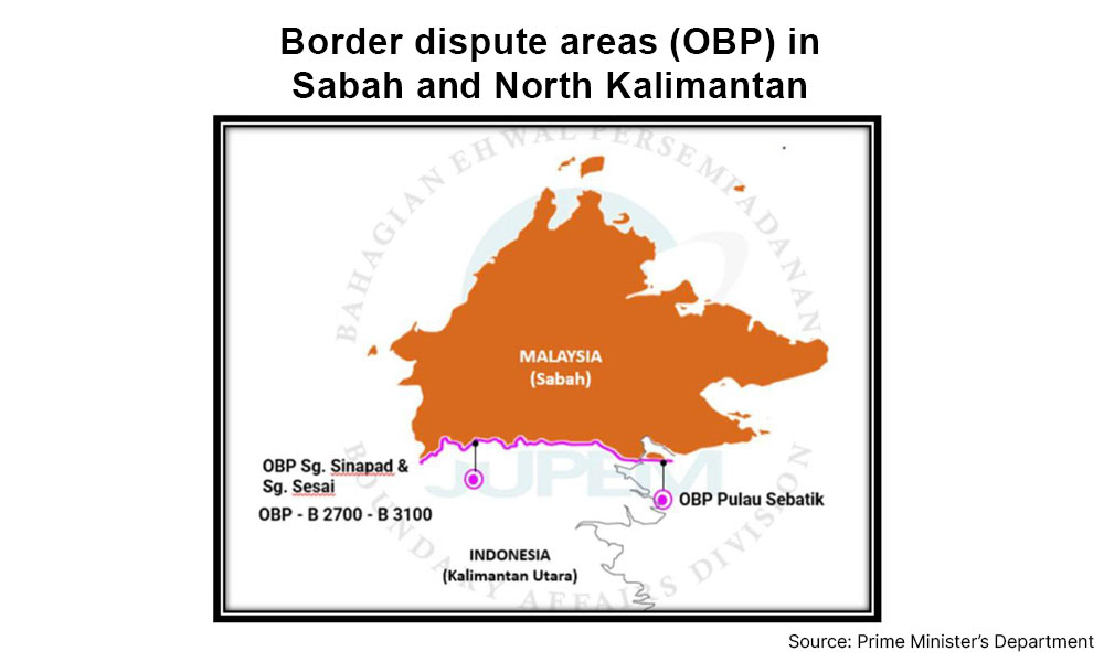
Anwar had told Parliament on Feb 4 that a redrawn boundary between parts of Sabah and North Kalimantan would see 785ha of 5,987ha of land that did not legally belong to either country falling under Malaysian jurisdiction, while the rest would be considered Indonesian territory.
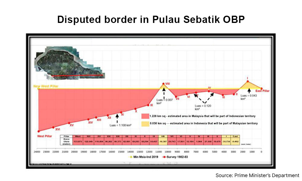
Of the 785ha, about 5ha are part of the Malaysia-Indonesia boundary in Pulau Sebatik.
When contacted, Ma’mun, a former Kalabakan MP, said the new boundary alignment will affect a stretch of land near Sungai Melayu and Sungai Haji Kuning, where the seven households are located.
“They have moved to Indonesia. They want to be Indonesians,” said Ma’mun, whose former parliamentary constituency includes Pulau Sebatik.
He added that once both governments formalise the agreement and the new border, the residents will be consulted for possible compensation and remedies.
It was previously reported that Nunukan regent H Irwan Sabri had said all residents affected by the new boundary will remain Indonesian citizens “as their villages are located in areas that are legally recognised as Indonesian territory”.
“At present, the central government in Jakarta is formulating special policies to improve development and the welfare of local communities in those areas,” Irwan had told Malaysiakini.
Ma’mun and Manahing said they sought clarification from survey officials, who explained that the dispute goes back to colonial-era boundary drawings.
A porous island
According to previous news reports and checks on Google Maps, the 452 sq km Pulau Sebatik, which is 20 sq km smaller than Pulau Langkawi, is divided almost evenly between Malaysia and Indonesia.
The land boundary cuts across the island and at its eastern tip, leaving parts of the surrounding maritime boundary historically disputed, such as the waters in the Ambalat issue in 2005.
Those who have visited the island’s border recounted how the boundary is only marked by concrete pillars, with no fencing, immigration posts or customs facilities.
The porous nature of the border area has also made the island a popular smuggling point, with enforcement agencies on both sides regularly intercepting shipments such as the supply of subsidised diesel in January.
In the Parliament briefing, Anwar said the area along the border in Pulau Sebatik, which had been classified as an Outstanding Border Problem (OBP), does not legally belong to any country but is being administered by Indonesia pending an official conclusion to the negotiations on the new border alignment in those areas.

No man’s land
Manahing, who is a former Sebatik assemblyperson, said Jupem officers informed them that the problem stemmed from the fact that the border between the two countries had been drawn manually during the British and Dutch colonial administrations.
“It was based on agreements between the British and the Dutch. It was done manually, so the accuracy was not precise,” Manahing told Malaysiakini.
Anwar had told Parliament that a 1915 British-Dutch agreement had set the boundary along Pensiangan and Lumbis, North Kalimantan, according to the location of the Sungai Sinapad-Sungai Sesai estuary.
But a survey between both nations in 1977 found that the 1915 map of the boundary had erroneously placed the estuary, so negotiations began on demarcating a new border between Pensiangan and Lumbis.
The new border alignment will see 780ha of land falling under Malaysian territory, including parts of three Indonesian villages - Kabulangalor, Desa Lepaga, and Desa Tetagas.
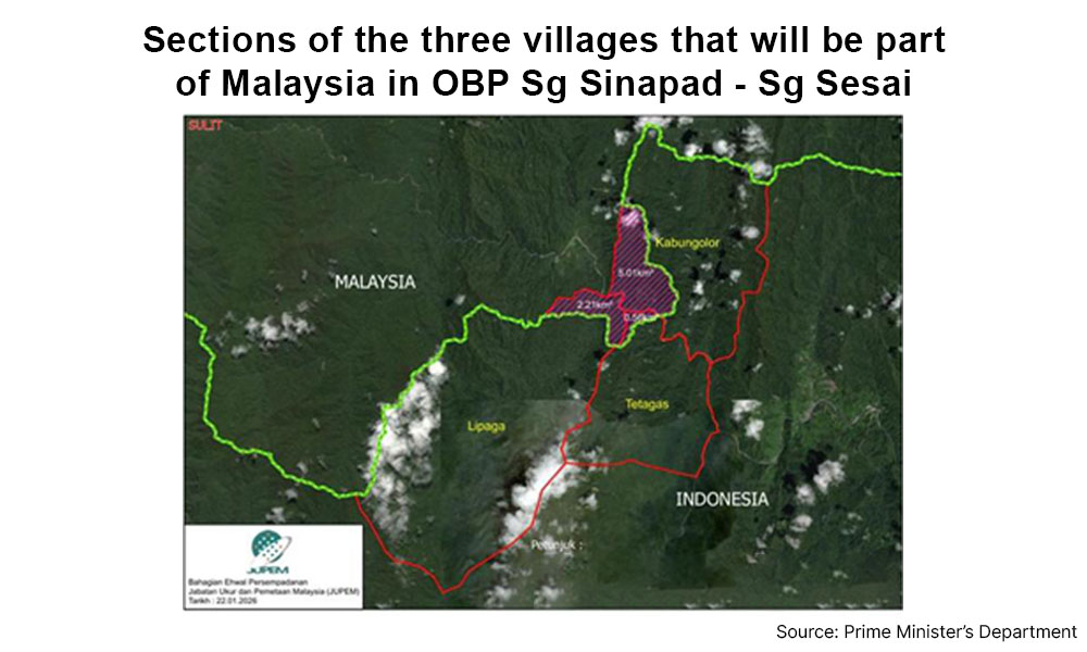
Ma’mun said the area on the Malaysian side contains no settlements.
“There is no village there. No settlement. It is a forest,” he said.
Manahing described the inland terrain as “no man’s land”, as it is connected to the rugged Crocker Range.
Both Manahing and Ma’mun described the border adjustment as a technical adjustment of historical survey inaccuracies rather than a transfer of inhabited territory.
“It is not something to shout about,” Manahing added.
- Mkini
No comments:
Post a Comment
Note: Only a member of this blog may post a comment.